
ဖုဲင်:Himalayas and allied ranges NASA Landsat showing the eight thousanders, annotated with major rivers.jpg

နမူႏနာႏယို ပေႏတန်: ၈၀၀ × ၅၃၃ ပိစ်သယ်။ ပွုံႏယောင်ꩻစဲင်းစဲ့ အလင်ဖုံႏ: ၃၂၀ × ၂၁၃ ပိစ်သယ် | ၆၄၀ × ၄၂၆ ပိစ်သယ် | ၁၀၂၄ × ၆၈၂ ပိစ်သယ် | ၁၂၈၀ × ၈၅၃ ပိစ်သယ် | ၂၅၆၀ × ၁၇၀၆ ပိစ်သယ် | ၃၄၆၄ × ၂၃၀၈ ပိစ်သယ်။
မူလဖုဲင် (၃၄၆၄ × ၂၃၀၈ pixels, ဖုဲင်ပေႏတန် - ၁.၇၉ MB, MIME အစွိုးအမျိုꩻ: image/jpeg)
အအဲဉ်ႏချုတ်
| အွဉ်ႏနယ်ချက် |
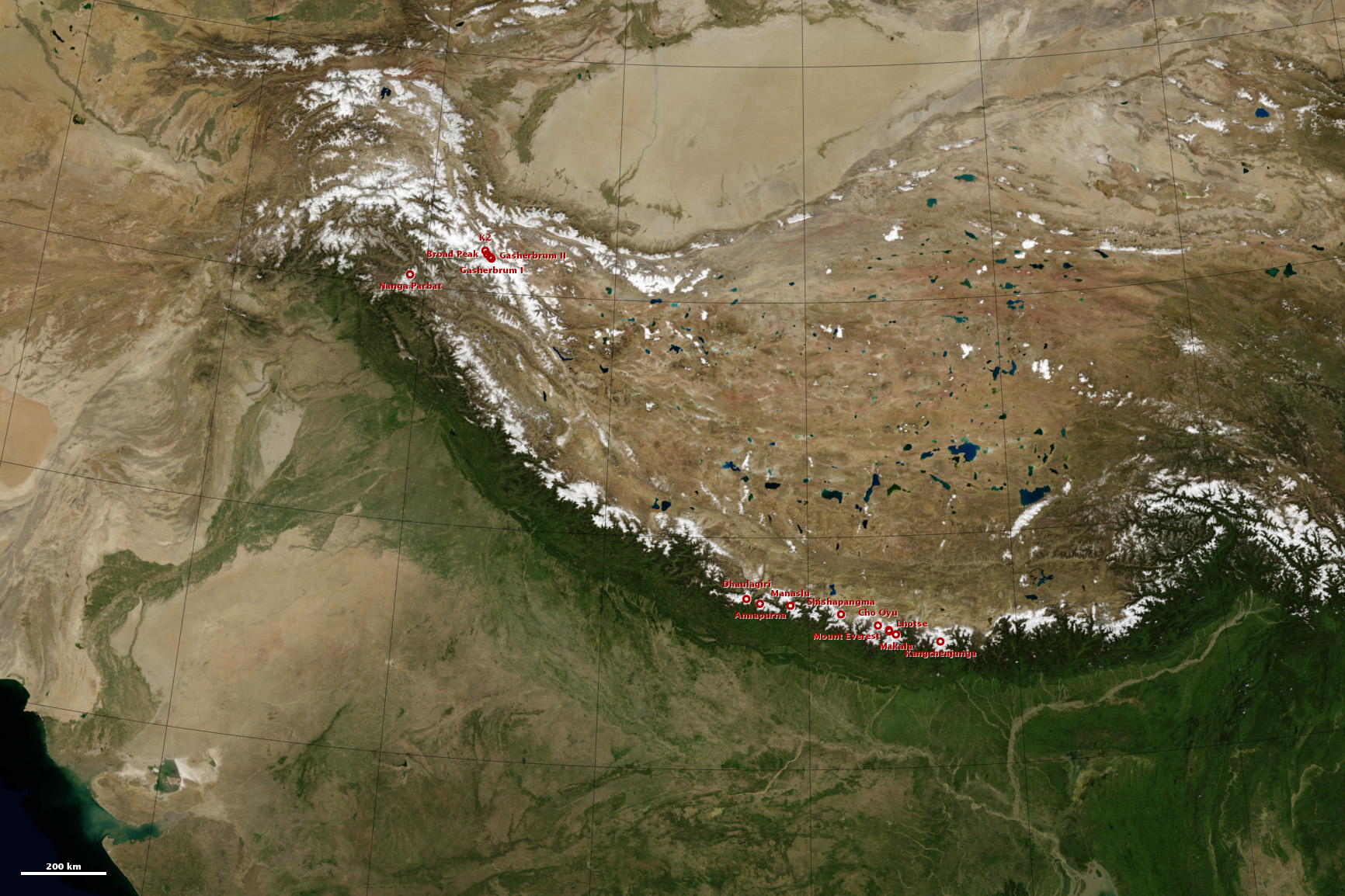
English: Himalayas and allied ranges in NASA Landsat image showing the eight thousanders, annotated with major rivers |
| မွူးနီꩻ | Taken on ၉ ဒီသဲဉ်ဗာ ၂၀၁၃, ၁၁:၅၆:၃၄ |
| ရွီးခိုႏ | https://eoimages.gsfc.nasa.gov/images/imagerecords/82000/82581/himalaya_map_color_lrg.jpg |
| တဲမ်းလိတ်သား | NASA Landsat image |
အွောန်ႏထွော့လုဲင်သိဉ်
| This file is in the public domain in the United States because it was solely created by NASA. NASA copyright policy states that "NASA material is not protected by copyright unless noted". (See Template:PD-USGov, NASA copyright policy page or JPL Image Use Policy.) | ||
 |
Warnings:
|
ဖုဲင်မုဲင်တန်ꩻ
ဖေႏကထီႏလꩻ ဖုဲင်နဝ်ꩻမွူးနီꩻအတွိုင်ꩻနဝ်ꩻ နျꩻသွော့ မွူးနီꩻ/အခိန်ႏ တဗာႏဗာႏလောင်း ကလိစ်သြ။
| မွူးနီꩻ/အခိန်ႏ | နမူႏနာႏပွုံႏစံႏပေႏ | ဒုဲင်မဲဉ်းသိဉ်းဖုံႏ | ကေားသုင်ꩻသား | တောင်ꩻသေꩻ | |
|---|---|---|---|---|---|
| ယိုခါကျာꩻ | ၀၉:၄၄၊ ၃၁ ဩဂဲစ် ၂၀၂၂ | | ၃၄၆၄ × ၂၃၀၈ (၁.၇၉ MB) | Fowler&fowler | Uploaded a work by NASA Landsat image from https://eoimages.gsfc.nasa.gov/images/imagerecords/82000/82581/himalaya_map_color_lrg.jpg with UploadWizard |
သုင်ꩻဖုဲင်
လိတ်မဲ့ငါလ့နဝ်ꩻနဝ်ꩻ အဝ်ႏသွုံꩻခါꩻ ဖုဲင်ယိုသွူ:
ဂလိုဗယ် သုင်ꩻဖုဲင်
ဝီခီအလင်ဖုံႏကို အဝ်ႏသွုံꩻခါꩻ ဖုဲင်ယိုသွူ:
- သုင်ꩻအီ bn.wikipedia.org ကို
- သုင်ꩻအီ bs.wikipedia.org ကို
- သုင်ꩻအီ el.wiktionary.org ကို
- သုင်ꩻအီ en.wikipedia.org ကို
- သုင်ꩻအီ eu.wikipedia.org ကို
- သုင်ꩻအီ id.wikipedia.org ကို
- သုင်ꩻအီ ml.wikipedia.org ကို
- သုင်ꩻအီ my.wikipedia.org ကို
- သုင်ꩻအီ ne.wikipedia.org ကို
- သုင်ꩻအီ uk.wikipedia.org ကို