
ဖုဲင်:Ecuador Topography.png

နမူႏနာႏယို ပေႏတန်: ၅၃၉ × ၆၀၀ ပိစ်သယ်။ ပွုံႏယောင်ꩻစဲင်းစဲ့ အလင်ဖုံႏ: ၂၁၆ × ၂၄၀ ပိစ်သယ် | ၄၃၁ × ၄၈၀ ပိစ်သယ် | ၉၀၃ × ၁၀၀၅ ပိစ်သယ်။
မူလဖုဲင် (၉၀၃ × ၁၀၀၅ pixels, ဖုဲင်ပေႏတန် - ၈၆၄ KB, MIME အစွိုးအမျိုꩻ: image/png)
အအဲဉ်ႏချုတ်
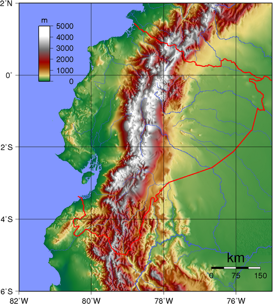
| အွဉ်ႏနယ်ချက် | Topographic map of Ecuador. Created with GMT from public GLOBE data. |
| မွူးနီꩻ | |
| ရွီးခိုႏ | နမ်းပဲင်ႏဖန်ဆင်ꩻမုꩻ |
| တဲမ်းလိတ်သား | Sadalmelik |
အွောန်ႏထွော့လုဲင်သိဉ်
| This work has been released into the public domain by its author, I, Sadalmelik. This applies worldwide. In some countries this may not be legally possible; if so: I, Sadalmelik grants anyone the right to use this work for any purpose, without any conditions, unless such conditions are required by law. |
ဖုဲင်မုဲင်တန်ꩻ
ဖေႏကထီႏလꩻ ဖုဲင်နဝ်ꩻမွူးနီꩻအတွိုင်ꩻနဝ်ꩻ နျꩻသွော့ မွူးနီꩻ/အခိန်ႏ တဗာႏဗာႏလောင်း ကလိစ်သြ။
| မွူးနီꩻ/အခိန်ႏ | နမူႏနာႏပွုံႏစံႏပေႏ | ဒုဲင်မဲဉ်းသိဉ်းဖုံႏ | ကေားသုင်ꩻသား | တောင်ꩻသေꩻ | |
|---|---|---|---|---|---|
| ယိုခါကျာꩻ | ၀၂:၀၂၊ ၁၃ ဇွန် ၂၀၀၇ | | ၉၀၃ × ၁၀၀၅ (၈၆၄ KB) | Sadalmelik | {{Information |Description=Topographic map of Ecuador. Created with GMT from public GLOBE data. |Source=self-made |Date=June 12, 2007 |Author= Sadalmelik }} Category:Maps of Ecuador Category:Topographic maps of the Americas |
သုင်ꩻဖုဲင်
လိတ်မဲ့ငါလ့နဝ်ꩻနဝ်ꩻ အဝ်ႏသွုံꩻခါꩻ ဖုဲင်ယိုသွူ:
ဂလိုဗယ် သုင်ꩻဖုဲင်
ဝီခီအလင်ဖုံႏကို အဝ်ႏသွုံꩻခါꩻ ဖုဲင်ယိုသွူ:
- သုင်ꩻအီ af.wikipedia.org ကို
- သုင်ꩻအီ ar.wikipedia.org ကို
- သုင်ꩻအီ azb.wikipedia.org ကို
- သုင်ꩻအီ bg.wikipedia.org ကို
- သုင်ꩻအီ bn.wikipedia.org ကို
- သုင်ꩻအီ da.wikipedia.org ကို
- သုင်ꩻအီ de.wikipedia.org ကို
- သုင်ꩻအီ en.wikipedia.org ကို
- သုင်ꩻအီ en.wikiquote.org ကို
- သုင်ꩻအီ eu.wikipedia.org ကို
- သုင်ꩻအီ fa.wikipedia.org ကို
- သုင်ꩻအီ fr.wikipedia.org ကို
- သုင်ꩻအီ hu.wikipedia.org ကို
- သုင်ꩻအီ it.wikipedia.org ကို
- သုင်ꩻအီ ja.wikipedia.org ကို
- သုင်ꩻအီ ka.wikipedia.org ကို
- သုင်ꩻအီ nds-nl.wikipedia.org ကို
- သုင်ꩻအီ pt.wikipedia.org ကို
- သုင်ꩻအီ qu.wikipedia.org ကို
- သုင်ꩻအီ ru.wikipedia.org ကို
- သုင်ꩻအီ sd.wikipedia.org ကို
- သုင်ꩻအီ te.wikipedia.org ကို
- သုင်ꩻအီ tr.wikipedia.org ကို
- သုင်ꩻအီ tt.wikipedia.org ကို
- သုင်ꩻအီ uk.wikipedia.org ကို
- သုင်ꩻအီ ur.wikipedia.org ကို
- သုင်ꩻအီ vep.wikipedia.org ကို
- သုင်ꩻအီ zh.wikipedia.org ကို