အီကွေတာ

အဝ်ႏ ဝီခီပီးဒီးယား ကို
ကမ္ဘာႏဟံႏပုင်ႏကို ကအဝ်ႏဒါႏ အီကွေတာသီး
ခမ်းထီတောမ်ႏဒေႏသဖုံႏ ကအဝ်ႏခွိုင်းဒင်ႏဒါႏ အီကွေတာ (တနျာႏ)

အီကွေတာသီး (အိန်းကလေတ်: Equator) ကရိုꩻနဝ်ꩻ ကမ္ဘာႏဟံႏမဲ့ငါခိုႏ အထာႏဝလောင်း တောမ်ႏသꩻစိတ်ကူꩻထာꩻယူႏတွော့ꩻ ကတဲမ်းထွို့ꩻခါꩻဒျာႏ သီး(မျဉ်း)တဗာႏဒျာႏသွူ။ အီကွေတာယို တောမ်ႏကမ္ဘာႏဟံႏဝင်ရိုးနဝ်ꩻ အဝ်ႏထဲ့တနꩻ (ဒေါင်လိုက်)ကီလနဝ်ထင်ꩻဝင်ꩻတဲင် အဝ်ႏလွေꩻ ကမ္ဘာႏဟံႏအခဝ်ထင်ꩻတောမ်ႏ ကမ္ဘာႏဟံႏအခဝ်နဝ် အခါႏကိုနဝ်ꩻသွူ။ ဒေႏသရပ်ရာႏ ကအဝ်ႏဗွော့ꩻဒါႏ အီကွေတာထျꩻ ဥတုရာႏသီႏနဝ်ꩻ ထွာခမ်းလျားနဝ်ꩻသွူ။ အီကွေတာယို ကမ္ဘာႏလောင်းနဝ်ꩻ အဝ်ႏလွေꩻ လတ္တီစျု 0 ဒီဂရီကိုတဲင် ပတ်ဝွိုင်ꩻ(လုံးပတ်)နဝ်ꩻ အဝ်ႏ ၄၀,၀၇၅ ကီလိုမီတာ (၂၄,၉၀၁ မဲင်ႏ) ရပ်၊ အဝ်ႏခွဲꩻဖြယ်ခါꩻဖေႏ ကမ္ဘာႏဟံႏ အခဝ်နဝ်တောမ်ႏအခဝ်ထင်ꩻ နီခဝ်နဝ်ꩻသွူ။[၁]

အီကွေတာထျꩻ ရာႏသီႏဥတု[မွဉ်းဖျင် | မွဉ်းဖျင်အရွီးခိုႏ]

အီကွေတာသီးယို တောမ်ႏမွူးနဝ်ꩻ အဝ်ႏတောက်ꩻတနျꩻလွေꩻဝင်ꩻတဲင် ဒေႏသရပ်ရာႏ ကအဝ်ႏဗွော့ꩻဒါႏ အီကွေတာထျꩻ ဥတုရာႏသီႏနဝ်ꩻ ထွာခမ်းလျားနဝ်ꩻသွူ။


Diagram of the seasons, showing the situation at the December solstice. Regardless of the time of day (i.e. Earth's rotation on its axis), the North Pole will be dark, and the South Pole will be illuminated; see also polar night. In addition to the density of incident light, the dissipation of light in atmosphere is greater when it falls at a shallow angle.

အီကွေတာသီးထျꩻ ခမ်းထီတောမ်ႏဒေႏသဖုံႏ[မွဉ်းဖျင် | မွဉ်းဖျင်အရွီးခိုႏ]

Map all coordinates using: OpenStreetMap
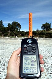
GPS reading taken on the Equator close to the Quitsato Sundial, in Cayambe, Ecuador[၂]
Sign on the equator in San Antonio de Pichincha, Ecuador.

အီကွေတာနဝ်ꩻ အဝ်ႏဖျတ်ကာႏလွေꩻ အာႏဏာႏပဲင်ႏခမ်းထီဖုံႏ ၁၁ ခမ်းသွူ။ အိဉ်ဒိုနီးသျားခမ်းထီနဝ်ꩻ ကာႏသွူ ပင်ႏလယ်ႏတောမ်ႏကောင်သဲင်လောင်းတဲင် ထွာဒျာႏ အီကွေတာသီး အဆွာꩻသွတ်ꩻ ကကာႏလွေꩻဒါႏ ခမ်းဒျာႏသွူ။:

ကိုဩဒိနိတ် ခမ်းထီ မွေးတဝ်းလဲ့
ထီနမ်း
တောင်ꩻသေꩻ
0°N 0°E / 0°N 0°E / 0; 0 (Prime Meridian) အတ်တလန်တိတ် သမုဒ္ဒရာႏ Gulf of Guinea, "Null Island"
0°0′N 6°31′E / 0.000°N 6.517°E / 0.000; 6.517 (São Tomé and Príncipe) တမ်းပလေက်:STP Passing through Pestana Equador resort on the Ilhéu das Rolas
0°0′N 9°21′E / 0.000°N 9.350°E / 0.000; 9.350 (Gabon)  ဂါဗွန် Passing ၈.၉ km (၅.၅ mi) south of Ayem, ၁၀.၆ km (၆.၆ mi) north of Mayene, Booue
0°0′N 13°57′E / 0.000°N 13.950°E / 0.000; 13.950 (Republic of the Congo)  ကွန်ဂို Passing through the town of Makoua.
0°0′N 17°45′E / 0.000°N 17.750°E / 0.000; 17.750 (Democratic Republic of the Congo)  ကွန်ဂိုဒီမိုကရဲတ်တိစ်ခမ်းနမ်းဗွေႏ Passing ၉ km (၅.၆ mi) south of central Butembo
0°0′N 29°44′E / 0.000°N 29.733°E / 0.000; 29.733 (Uganda) တမ်းပလေက်:UGA Passing ၃၂ km (၂၀ mi) south of central Kampala
0°0′N 32°13′E / 0.000°N 32.217°E / 0.000; 32.217 (Lake Victoria) Lake Victoria Passing through some islands of တမ်းပလေက်:UGA in Mukono District and Namayingo District
0°0′N 34°0′E / 0.000°N 34.000°E / 0.000; 34.000 (Kenya) တမ်းပလေက်:KEN Passing ၆ km (၃.၇ mi) north of central Kisumu Passes through the highest mountain in Kenya i.e Mt. Kenya
0°0′N 41°0′E / 0.000°N 41.000°E / 0.000; 41.000 (Somalia) တမ်းပလေက်:SOM Passing south of Jamame
0°0′N 42°53′E / 0.000°N 42.883°E / 0.000; 42.883 (Indian Ocean) Indian Ocean Passing between Huvadhu Atoll and Fuvahmulah of တမ်းပလေက်:MDV
0°0′N 98°13′E / 0.000°N 98.217°E / 0.000; 98.217 (Indonesia) တမ်းပလေက်:IDN North Sumatra (Batu Islands), West Sumatra (West Pasaman, Pasaman and Lima Puluh Kota Regency), Riau (Kampar, Pelalawan and Indragiri Hilir Regency), and Lingga Regency of Riau Islands
0°0′N 104°35′E / 0.000°N 104.583°E / 0.000; 104.583 (South China Sea) South China Sea
0°0′N 109°10′E / 0.000°N 109.167°E / 0.000; 109.167 (Indonesia) တမ်းပလေက်:IDN Bornean provinces of West Kalimantan (passing through province capital Pontianak), Central Kalimantan, and East Kalimantan
0°0′N 117°31′E / 0.000°N 117.517°E / 0.000; 117.517 (Makassar Strait) Makassar Strait
0°0′N 119°40′E / 0.000°N 119.667°E / 0.000; 119.667 (Indonesia) တမ်းပလေက်:IDN Donggala & Parigi Moutong Regency, Central Sulawesi (Celebes)
0°0′N 120°6′E / 0.000°N 120.100°E / 0.000; 120.100 (Gulf of Tomini) Gulf of Tomini
0°0′N 123°22′E / 0.000°N 123.367°E / 0.000; 123.367 (Molucca Sea) Molucca Sea
0°0′N 127°25′E / 0.000°N 127.417°E / 0.000; 127.417 (Indonesia) တမ်းပလေက်:IDN Kayoa and Halmahera islands, North Maluku
0°0′N 127°53′E / 0.000°N 127.883°E / 0.000; 127.883 (Halmahera Sea) Halmahera Sea
0°0′N 129°21′E / 0.000°N 129.350°E / 0.000; 129.350 (Indonesia) တမ်းပလေက်:IDN Gebe and Kawe islands, North Maluku, Southwest Papua
0°0′N 130°11′E / 0.000°N 130.183°E / 0.000; 130.183 (Pacific Ocean) Pacific Ocean Passing between Aranuka and Nonouti atolls, တမ်းပလေက်:KIR (at 0°0′N 173°45′E / 0.000°N 173.750°E / 0.000; 173.750)
Also passing just south of Baker Island, and just north of Jarvis Island, တမ်းပလေက်:UMI
0°0′N 91°35′W / 0.000°N 91.583°W / 0.000; -91.583 (Ecuador) တမ်းပလေက်:ECU Isabela Island in the Galápagos Islands
0°0′N 91°13′W / 0.000°N 91.217°W / 0.000; -91.217 (Pacific Ocean) Pacific Ocean
0°0′N 80°7′W / 0.000°N 80.117°W / 0.000; -80.117 (Ecuador) တမ်းပလေက်:ECU Passing ၂၄ km (၁၅ mi) north of central Quito, near Mitad del Mundo, and precisely at the location of Catequilla, a pre-Columbian ruin.
0°0′N 75°35′W / 0.000°N 75.583°W / 0.000; -75.583 (Colombia) တမ်းပလေက်:COL Passing ၄.၃ km (၂.၇ mi) north of the border with Peru
0°0′N 70°3′W / 0.000°N 70.050°W / 0.000; -70.050 (Brazil) တမ်းပလေက်:BRA Amazonas, Roraima, Pará, Amapá (passing slightly south of the city center of the state capital Macapá, and precisely at the Marco Zero monument and the Avenue Equatorial)
0°0′N 49°21′W / 0.000°N 49.350°W / 0.000; -49.350 (Atlantic Ocean) Atlantic Ocean At the Perigoso Canal (sv) on the mouth of the Amazon River

အာႏကွိုꩻ[မွဉ်းဖျင် | မွဉ်းဖျင်အရွီးခိုႏ]

  1. Equator (6 September 2011)။
  2. Instituto Geográfico Militar de Ecuador (24 January 2005)။ Memoria Técnica de la Determinación de la Latitud Cero (in es)။